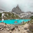
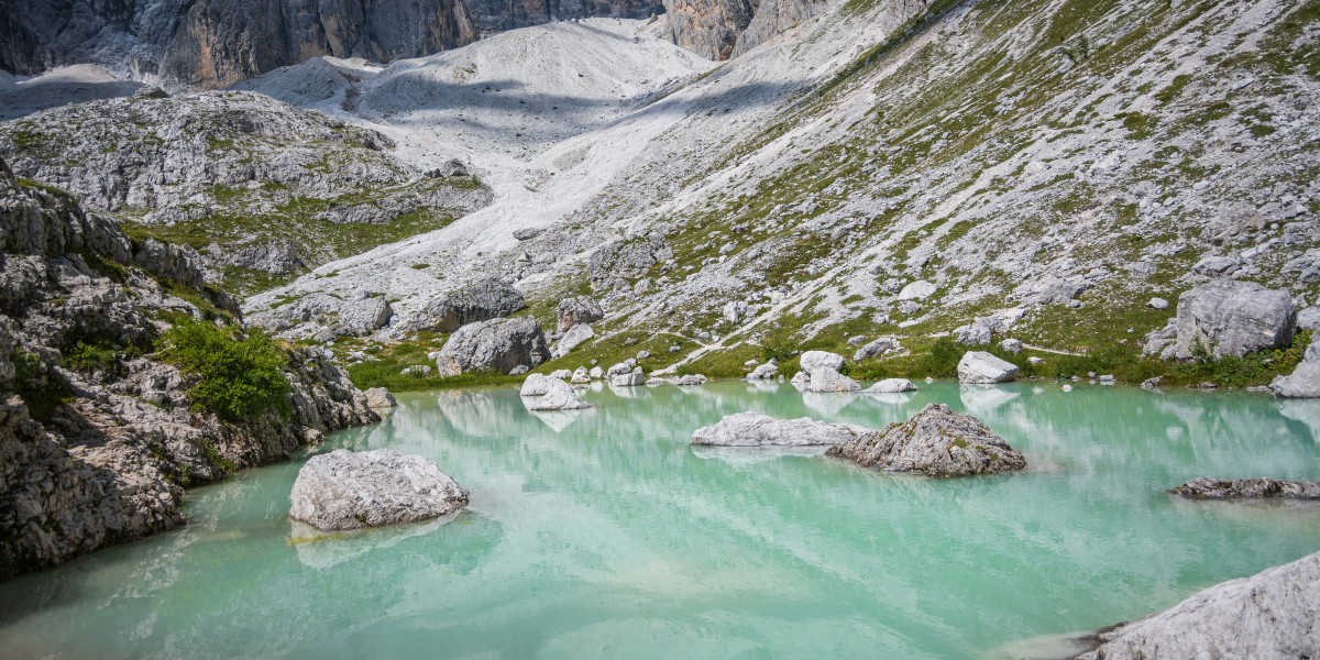
It may look as though someone has applied a filter, but it is pure geology. In the Ampezzo Dolomites, there is a lake with the pale, milky blue-green shade of mint milk, surprising even for people who have seen it countless times in photos.
This is Lake Sorapis, one of Veneto’s most photographed glacial lakes, sitting just below 2,000 metres and enclosed by an amphitheatre of bare rock faces. Its colour is no illusion. It is caused by mineral particles suspended in the water, which refract light in a distinctive way. Here is where it is and how to reach it safely.
Where Lake Sorapis is and why its water looks like mint milk
Lake Sorapis lies in the Belluno Dolomites, within the municipality of Cortina d’Ampezzo. It sits in the Sorapis massif, roughly 12 km from the town centre in the direction of Passo Tre Croci and Misurina.
The lake is just under 2,000 metres above sea level. Views along the route take in several Dolomites landmarks, including Monte Cristallo, the Popena group, the Cadini di Misurina and, in the distance, the Tre Cime di Lavaredo.
The lake is small, covering around 2.5 hectares, and shallow by Alpine standards, reaching a maximum depth of about 2.6 metres. There is no visible outlet. Its water disappears underground and re-emerges lower down at a waterfall called el Piss, a detail linked to the local etymology of the massif: Sora el Piss means ‘above the waterfall’.
The lake’s milky colour, which has made it so widely photographed, is explained by its glacial origins. Meltwater carries very fine mineral dust, which remains suspended in the water and scatters the light, creating that icy mint shade.
When to visit: water levels and colour change through the year
Lake Sorapis is usually full between June and August, when its colour is at its most intense thanks to active glacial meltwater. In early June, especially after snowy winters, sections of the paths can still be covered in snow or ice. This considerably increases the difficulty for people without mountain experience.
From late August into autumn, water levels tend to fall. Parts of the lakebed emerge, and the colour may look less even, though this does not signal a problem with the lake.
In winter, the basin is blanketed in snow, the surface may freeze, and the turquoise colour almost disappears beneath the white. Trails become more difficult due to ice and, in some sections, avalanche risk. At this time of year, the ascent is not recommended for inexperienced hikers.
How to reach Lake Sorapis: trails 215 and 217
Sorapis cannot be reached by car. The lake is accessible only on foot, via mountain trails. This is not an urban stroll: the routes involve changes in elevation, exposed sections and passages where a sure footing is needed.
There are two main marked routes: trail 215 from Passo Tre Croci, the more frequently used option, and trail 217 from Val d’Ansiei, which is steeper and more rugged.
Trail 215 from Passo Tre Croci
Trail 215 begins at Passo Tre Croci, at roughly 1,800 metres above sea level, and enters a conifer forest. The first stretches are relatively gentle, with glimpses of Monte Cristallo. The route then becomes more varied, with ups and downs, rock steps and exposed tree roots, eventually reaching equipped sections with short metal ladders, footbridges and safety cables along narrow ledges.
It is not a via ferrata, but anyone with a fear of heights or travelling with very young children should consider the route carefully. The total ascent is around 300 metres, and the round trip covers approximately 11 km. Typical timings are about two hours uphill and another two hours downhill, although these vary according to pace and crowds. Shortly before the lake is Rifugio Alfonso Vandelli, a mountain hut with views across the valleys and visible during the final part of the walk.
Trail 217 from Val d’Ansiei
The route starts near the former Albergo Cristallo, crossing meadows and old wooden buildings. After a long, mostly level stretch through the forest, the path steepens considerably. The climb gains around 550 metres of elevation over just more than 4 km. There are exposed ledges and easy rocky sections where using your hands for balance may sometimes be necessary.
There are no chains or ladders as on trail 215, but the setting is more austere and the gradient calls for good fitness and constant care. The reward is the view behind, across the Cadini di Misurina, the Tre Cime and Lake Misurina, high in the valley, before the trail joins route 215 shortly before Rifugio Vandelli.
Alternatives for experienced hikers
There is a longer, less busy circular route that begins at Passo Tre Croci, climbs to Forcella Marcoira along trails 213 and 216, crosses Ciadin del Loudo and returns via trail 215. It has an elevation gain of around 700 metres, including short equipped sections and more open views across Monte Cristallo, the Tofane group and the Sesto Dolomites.
It should only be considered by people with good hiking experience and in stable weather, taking into account the greater exposure and the time required.
What is at the lakeside: the Finger of God, mountain hut and rules
Arriving at Lake Sorapis feels dramatic. The path suddenly opens onto the shore, where three striking features come into view: the milky water, the ‘Finger of God’ rock pinnacle, rising above 2,600 metres, and a quiet that gives way to the murmur of visitors during the busiest periods.
A few minutes away, Rifugio Alfonso Vandelli provides refreshments, local dishes and information about the trails. Overnight stays are available by reservation, with limited beds and shared facilities. It mainly opens during the peak summer season.
This is a fragile environment, and clear rules apply. Since 1 August 2019, an ordinance issued by the Cortina d’Ampezzo council has banned swimming, with fines of up to €500. Entering the water could upset its delicate balance, while the lakebed is not visible. Camping is not permitted on the shore or in the immediate surrounding area, and the lake cannot be reached by bicycle because of the narrow and exposed paths.
Transport and practical details: reaching the trailheads
For trail 215, Passo Tre Croci can be reached from Cortina d’Ampezzo by following the state road towards Misurina. It can also be approached from Val Pusteria, such as Dobbiaco, crossing Val di Landro and turning off before entering Cortina.
During peak season, car parks fill up early. Setting off early in the morning can help avoid queues and heavy footfall on the trail. Those travelling without a car can get close to Passo Tre Croci on scheduled bus services, with connections from Cortina or the Dobbiaco/Misurina area varying by season.
Trail 217 begins in Val d’Ansiei, near the former Albergo Cristallo. Parking is available along the road and in the spaces in front of the building.
Article originally published by The Wom: “L’acqua sembra latte alla menta: lo specchio d’acqua più incredibile del Veneto…”